The Moray Firth Coastline is a very special place, with its many beautiful beaches, rugged cliffs and harbour towns and villages.
The North East of Scotland has a long and often exciting history, and you can visit sites which go back long before even the Romans arrived here – although they only stayed briefly! The Picts have left their mark (indeed, within a stone’s throw of Burghead Cottage), while colourful characters such as the Wolf of Badenoch pepper the medieval period. Click here for a very good article about the history of Moray.
Of course, each of our lovely holiday cottages has its own very particular local context:

Lossiemouth can be found on the Moray coast some five miles north of Elgin. Major development of Lossiemouth did not take place until the 1800s. Today’s Lossiemouth has seen many changes. The eastern harbour has been converted into a spectacular yachting marina, while the railway sheds that used to service it have been swept away in favour of harbourside houses and flats. The northern harbour continues to protect vessels of all shapes and sizes; and there remains a resident fishing fleet and a fishmarket there.
Lossiemouth has a welcoming atmosphere and visitors can also enjoy two superb beaches here. One, West Bay, stretches for three miles to the west, beyond the headland housing Covesea Lighthouse. The East Beach extends even further to the east of Lossiemouth. It begins with the spitof sand and dunes backed by the length of the River Lossie as it parallels the sea before emerging in Lossiemouth. It is reached by pedestrian bridge from Seatown. The dunes backing the East Beach were created deliberately in the early 1900s by placing disused railway carriages behind the beach. The intention was to provide better protection for the Seatown cottages.
Lossiemouth also offers visitors a range of golfing opportunities, including the Moray Golf Club on the west side of the town, overlooking the West Bay. Also on the west side of the town are the landing lights signifying the end of one of the runways of RAF Lossiemouth. The RAF station opened in 1939 and has since become an integral part of the local community, providing a home for Tornado aircraft.
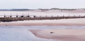
The white sands of East Beach beyond the breakwater
In 1835 the Lord of Pitgaveny opened a small harbour in what is now the north end of the yachting marina. This surrounding area became known as Branderburgh, to distinguish it from the small village of Stotfield, a little further to the west. Branderburgh Harbour was designed to carry the commercial traffic that until then had relied on the mouth of the River Lossie. Branderburgh grew in the latter half of the 1800s and as it merged into Seatown and Stotfield, the area came to be called Lossiemouth, or simply Lossie. The harbour on the east side of Lossiemouth was extended with the railway link from Elgin; and at about the same time the fishing fleet started to move from the river to the harbour. On 12 October 1866, Ramsay MacDonald later to become Britain’s first Labour Prime Minister, was born in Lossiemouth.
Seatown was built, circa 1835, a short distance inland along the River Lossie. Its 51 cottages were intended to provide accommodation for the fishermen, who continued to use the river as their harbour. Seatown was sometimes referred to as the Dogwall, a reference to dog-skins that were dried here before being turned into floats for nets.
S andend Village was established by the early 1600s and is one of the earliest fishing communities on the Aberdeenshire Coast although many of the older fisher cottages and the harbour you see today, were built in the 1800’s. You will find a unique cluster of charming fishing cottages around the characteristic harbour.
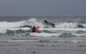
Kayaking and surfing are both popular activities at Sandend
Sandend is a magnet for surfers who travel from all over the country to ride the waves that crash onto the long, sandy beach which, unsurprisingly, gave the village its name! The waves here are regarded as being among the best waves in the country – surfers often say it’s like Cornwall without the crowds… And a visit to the local Glenglassaugh Distillery is sure to provide some warmth after a dip in the sea!
Visitors to the beach can also see the remains of World War II anti-tank positions and pill box defences!
Portsoy
Portsoy was created a burgh of barony in 1550. It was given by Mary, Queen of Scots to Sir Walter Ogilvie of Boyne.
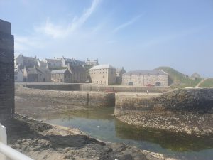
The first harbour was built at around the same time but was replaced in 1692 by Sir Patrick Ogilvie, the 8th Laird of Boyne with the one you see now, built entirely of stone. Large stones were set vertically as it was said this made them less likely to be washed away by the sea. Portsoy’s harbour was considered to be the safest in the North East, which meant that it had a thriving trade with both England and the Continent.
The Lairds of Boyne built the Palace of Boyne in the 1570s, which was still being used as a grand house in the mid 1700s when the Ogilvies’ support for the Jacobite cause led to their being stripped of their lands. Its ruins can now be seen two miles (3.5 kilometers) to the east of Portsoy.
The new harbour was built between 1825-28 to meet the demands of the herring boom and the volume of trade going through Portsoy. Throughout the nineteenth century a herring boom brought further prosperity to Portsoy, with a herring fleet totalling 57 boats at its peak, though usually averaging 40-50 boats in harbour employing 108 resident fishermen and boys.
The harbour was washed away in an extremely violent storm in January 1839 and was only rebuilt in 1884 to hold 12 vessels of 100 tons, though most ships visiting the harbour were much smaller. The main imports were coal and bones from the Baltic, and the chief exports grain, herring, and potatoes.
Towards the end of the nineteenth century the Portsoy fishing fleet moved to the larger harbours of Macduff and Buckie and today Portsoy’s harbours are primarily used by pleasure craft and creel boats catching lobster and crab. Portsoy is home to the popular Scottish Traditional Boat Festival. The Salmon Bothy, a local museum, venue and heritage centre is a good place to start if you are wanting to trace your ancestors in the North East of Scotland. Further advice and resources are available at northeastscotlandroots.com
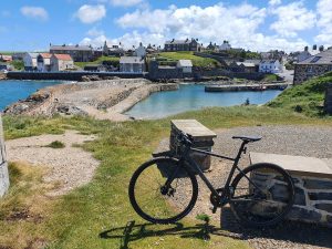
Burghead’s history dates back to the Neolithic times, but the first fort was built in the 5th century as the town was a power centre for the Northern Picts. The fort was destroyed in the 9th century as power moved from this coastal stronghold to Duffus further inland. Much of the fort was still in evidence in the 18th century but everything changed in 1805 when a much larger settlement on a regular, gridded street plan was laid out. From 1807 the harbour you see today was built by Thomas Telford and Burghead rapidly became an important herring fishing port. The result was a thriving town, but in the process most of the pictish fortifications were obliterated and today only partial remains can be seen around the outer end of the headland. By 1834 Burghead was home to 40 fishing boats. The fishing industry has declined in recent years, but Burghead remains home to a number of vessels. More recently Burghead became an important centre for the malting industry, with barley being malted here for usein Speyside’s many distilleries. A further large maltings was built a little to the south of Burghead at Roseisle, where Diageo has its latest distillery. Burghead today is an attractive mix of planned town, harbour and holiday resort. Little may remain of the pictish fortifications on the headland, but the area does afford wonderful views back over the town and along the coast.
For further information and details, see the following links:
Undiscovered Scotland – The best online guide to Scotland that we have found!
Angela Oatridge’s guide to Burghead in brief, including the Fort, the Well, the Visitor Centre, the Burning of the Clavie, walks, dolphins etc